Getting There: Bicycling Bermuda Triangles
Thanks to everyone who weighed in with route ideas for getting from Tempe to downtown Phoenix. Clearly there’s a wide variety of ways to get from here to there, with varying degrees of adventure and distance involved. On a recent trip in early February, I have noted that it’s possible to travel west along Washington to 24th Street before construction starts to make things a bit crazy (rough road, no bike lane, no shoulder). I can’t wait until the whole thing’s finished! In the meantime, you’ve come up with some good alternative ideas.
Your responses got me wondering about something else: as I ride around, I often take mental note of particular areas that are challenging or annoying to navigate by bicycle, which I’ll refer to as Bicycling Bermuda Triangles (BBTs). One of my criteria for a nice bike route is that it should not require riding on sidewalks at all, so for me one BBT is reaching the Tempe Public Library (southwestern corner of Rural and Southern): I can take College Ave. most of the way there, and then turn left on Malibu Dr. (just south of Southern), but that spits me back out on Rural or Southern before I reach the library, so I end up on the sidewalk for at least a short stretch because traffic travels too quickly on both Rural and Southern for me to feel safe on the road by myself at night. I’ve often wondered if there’s a sneaky back entrance among the houses behind the Tempe Library complex, but if there is I’ve never found it.
Another spot is the corner of Rural and Broadway, where it’s possible to get almost to the intersection on the frontage road on the north side of Broadway, but then at the last moment things get dangerous due to a bus stop and a parking lot exit where drivers generally don’t watch for bicycles traveling against traffic (and I can’t say I blame them).
So my question for you is, have you encountered other BBTs of your own? How have you learned to deal with them? Are you happy just “making do” with what’s there, or can you envision some kind of reasonable potential change to make things better? (I must admit that I have dreams of bike lanes along Broadway, Rural, and Southern, or at least dreams of slower speed limits so I’m not worried about being killed by cars)

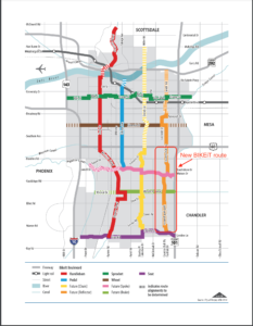



To avoid BBTs I use Google Earth and zoom in and study the aerial photos. Also, when I have to take a route on a bike that is new, I usually have the lovely wife drive it as I sit in the passenger seat and study the route and potential pitfalls.
Rather than posting lists here, we could use one of the bike route web “mashups” around like http://www.bikely.com/, or http://www.routeslip.com to post annotated bike routes. I know some work better than others on windows v mac etc. and some are down more than others. I’d like to have a way to flag areas that could help the city plan and maintain the roads.
I’d love to get a little gps that I could hook up to the computer network and upload a route with all the little bike secrets that we learn to get around without getting mooshed.
So many bike routes are orphaned inside a residential neighborhood, without connectors to other routes or destinations; it’s a universal problem that can improve with our involvement if we had a way to document the need.
PS: One more bike route site I liked enough to put on my toolbar: mapmyride.com
Rino: I find Google Earth reasonably helpful as well–you’re lucky to have the luxury of someone to drive you through the route!
And Bill: That’s quite true, it would be great to have a way to flag areas. Up in Washington, a woman put together a website called Bicycle Watchdog (http://www.bicyclewatchdog.org/index.php) to do a similar sort of thing. If there’s enthusiasm for such a project, we (the collective “we”) could definitely get that sort of thing started. I bet the City would love to have documentation of such spots as well as a chance to show us how they’re working to address such spots.
Hmm, a GPS unit for bikers. I see a market there.
A site already exists for the PHX area to flag bicycle oriented hazards:
http://phoenix.therightride.org/
Thanks to Jeff over at the http://thevelorution.blogspot.com/ for bringing this site to my attention.
-cc
You can use the orbit to get to the library. Bike on bus free
I myself just take the lane on Southern only problems is the back up on rural and Southern.
I
Some us like Ben ride on Southern frequently. I ride the Rural to Price stretch daily. As Ben said you must take the outside lane. Having a mirror may help you get used to rear approaching motorists.
I do think Southern would benefit with a wide (15′) outside lane, but not with a bike lane stripe as there are so many side intersections with Southern that the turning conflicts would be too great.
Al
I like the phrase bicycle bermuda triangles (BBT’s). I am going to start using this in meetings at city hall to get points across. thanks!
Here’s an interesting project: http://www.petitiononline.com/bikether/petition.html